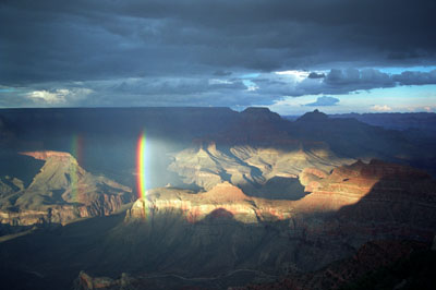
Double Rainbow in the Canyon Print No. B96-16
Looking north from Yaki Point, September 1996 - Just as the sun entered the narrow slot between the base of the clouds and the flat horizon far to the west, light drizzle fell into the canyon creating this double rainbow. As the sun continued to set, the rainbow grew until it became a complete double rainbow exceeding 180o. This image was Weatherwise Magazine's 1997 Grand Prize Winner and issue cover.
More Images of Rainbows
See this double
rainbow in motion. (220 Kb)
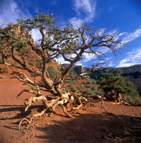
Walking Tree of the Kaibab Trail
About 1,500 feet (450 meters) below the south rim of the Grand Canyon, and about 1.5 miles (2.5 Km) down the Kaibab Trail, lies this pinyon pine clinging to the eroding sandstone shelf. At some point in its life, this tree fell over. The branches on one side took over as the tree's canopy. Some branches on the other side took root. This image captured 2nd Prize in Earth Magazine's 1998 "Portraits of Earth Photo Contest".
Print No. A97SW-7-6
Check out a close-up of this photo and see some of its detail.
Here is another example of a "walking tree" from Bryce Canyon.

Cape Royal Sunset
Here's a view looking south from the North Rim of the canyon at sunset. At sunset, the blue afterglow of the Kaibab Limestone is contrast to the orange sunglow of the underlying Coconino Sandstone.
Print No. A97SW-33-2
More Images of Sunsets
Here's a view from this same spot after the sun set.

Anticrepuscular Rays, Grand Canyon
Taken from Yavapai Point on the South Rim, this view is toward the east a few minutes after the sun set in the west. anticrepuscular rays, also known as twilight rays, are an unusual natural phenomenon, resulting from reflections high in the atmosphere. Although the rays appear to converge at the antisolar point (directly opposite the sun's position), they are actually parallel (like railroad tracks appear to converge).
Print No. A97SW-31-3
More Images of Solar Rays
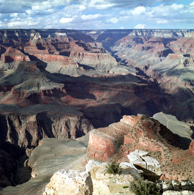
Bright Angel Canyon, Grand Canyon
Taken from Maricopa Point on the South Rim, this view is toward the northwest, looking up the Bright Angel Canyon. This side canyon to the Grand Canyon is conspicuously linear, thanks to the Bright Angel Fault that created it.
Print No. A03-7-8

Gorge Close-Up
From Maricopa Point, this is a close-up of the Colorado River gorge below Cheops Pyramid. Exposed in the gorge are the oldest rocks in the Grand Canyon, including the Precambrian-age Vishnu Schist and Zoroaster Plutonic Complex. These metamorphic and igneous rocks tend to be much denser than the overlying sedimentary rocks, and much more difficult for the river and tributaries to erode. This results in the steeper walls of the gorge.
Print No. A03-7-9
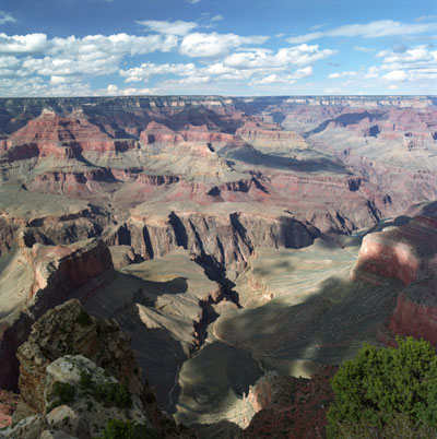
Hopi Point View
Looking northeast from Hopi Point, the Bright Angel Trail follows the near canyon to the Colorado River gorge. North of the gorge, Bright Angel Canyon (in the upper right) continues along its linear trend
Print No. A03-6-11

Hopi Point Sunset
This is looking east from Hopi Point just before sunset. Maricopa Point is on the far right. Vishnu Temple can be seen in the distance on the right.
Print No. A03-8-8
