
Trip into the Crater
Approaching the crater of Mount St. Helens from the north via helicopter, the steep crater walls and resurgent dome are seen straight ahead.
Print No. A01NW-9-7

Glacier around the Dome
Passing over the west side of the resurgent dome, a horseshoe-shaped rim of ice has gradually developed between the dome and the crater wall. This ice is hundreds of feet thick and has begun to move (making it a glacier) down to the north on either side of the dome. As it does, tension cracks have developed resulting in crevasses, and the hot gases around the base of the dome have formed ice caves. As the volume of ice within the crater increases, so does the threat of a glacial outbursts (like the one seen below) or deadly lahars.
Print No. A01NW-9-9
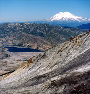
Sasquatch Steps
This is the view to the north from the Sasquatch Steps, the breached area to the north of the resurgent dome. Mount Rainier and Spirit Lake are in the distance. The drainage in the foreground is the upper portion of Loowit Canyon. The pinkish-gray rocks are mostly dacite lava, the same volcanic rock that comprises the dome. The white rocks are pieces of pumice left over from the explosive eruptions from 1980 to 1986.
Print No. A01NW-10-1
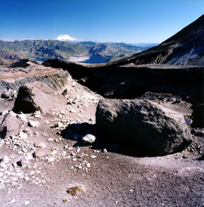
Mount Rainier and Spirit Lake
This is a closer look to the north at Mount Rainier and Spirit Lake from the front of the dome (taken from about half way up the north side of the dome). That's the northeastern edge of the crater wall in the foreground.
Print No. A01NW-13-2
Here are more images of Mount Rainier
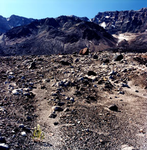
Recovering Flora
Looking south from the north side of the dome (Sasquatch Steps), a flowering plant can be seen in the lower left corner of the image. Very few plants have made it back this close to the crater's interior.
Print No. A01NW-10-8
Dome and Glacier
In this composition, also taken from the Sasquatch Steps, the dome rises over 1,000 feet (350 meters) above the plain on the left, and the toe of the glacier rises several hundred feet (up to 100 meters) above the plain on the right. Between and behind the two, a large crevasse can be seen on the glacier surface. In the background is the steep crater wall. Frequent rockfalls occur along the crater wall. Several members of the IGS team can be seen on the left side of the image.
Print No. A01NW-12-2

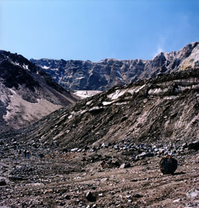
Toe of Glacier
From near the same spot as above, this view is towards the southwest. The toe of the glacier is seen in profile in front of the west crater wall. Visible in the crater wall is the composite nature of the Mount St. Helens volcano, with steeply-dipping layers of volcanic ash, lava flows and their feeder dikes.
Print No. A01NW-14-2

Glacial Outburst
While ascending the front (north) face of the resurgent dome, a large rock/mudslide occurred from the base of a sliver of glacial ice on the east wall of the crater. This is also known as a glacial outburst. In this image, you can see the motion of the mud and rocks (boulders) cascading down a channel just right and below the center of the image. A close-up of this image reveals its details.
Print No. A01NW-12-12

Geothermal Stream
Just north of the resurgent dome, both meltwater from the toe of the glacier and heated water from springs at the foot of the dome produce streams that have been carving the steep, narrow canyons in the volcano's breached north side. The temperature of some of the geothermal streams has been measured at 55oC (130oF). The foggy white appearance of this stream is the result of calcite (CaCO3) in solution. The calcite deposits on the banks downstream as the water temperature drops.
Print No. A01NW-13-10
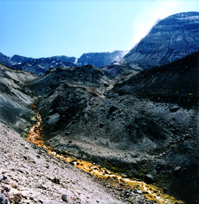
Red Sulfur Bacteria
Further to the northwest, this stream begins to carve deeply into the loose volcanic debris. Along the edges of the stream are bacteria that feed off the sulfur present in the geothermal water. The sulfur originated from volcanic gases, which are rising from the volcanic vent.
Print No. A01NW-14-7

Loowit Canyon
Along the eastern side of the Sasquatch Steps, Loowit Canyon is being carved by this stream. Just downstream of this point, the creek descends hundreds of feet down Loowit Falls. In September of 1997, a debris avalanche, triggered by heavy rains, sent a wall of mud and rocks 50 to 80 feet (15 to 25 meters) high through this canyon.
Print No. A01NW-15-9
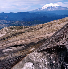
Mount Adams from Mount St. Helens
Looking east from the outer portions of the Sasquatch Steps, Mount Adams looms over the northeast edge of the crater wall. In the crater wall is a clear contact between dipping layers of basaltic lava flows (black layers in the lower left corner) and underlying highly-fractured dacite (light brown to white) from a 3,300 to 4,000 year old dome.
Print No. A01NW-15-6
Here are more images of the other Cascade Volcanoes of Washington
