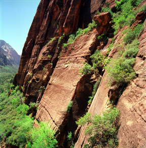
Cross Bedding in Navajo Sandstone
While ascending the switchbacks leading into Refrigerator Canyon, the view back to the south reveals this sheer exposure of Navajo Sandstone. In the surface highlighted by the Sun, several sets of cross-bedded sandstone are stacked one upon the other. Here is a close-up of the massive cross-bedded sandstone.
Print No. A01-31-9
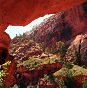
Overhang in Refrigerator Canyon
Portions of the trail dive under overhangs in the Navajo Sandstone within Refrigerator Canyon, providing some well-earned relief from the midday sun during the warmer times of the year.
Print No. A01-31-10
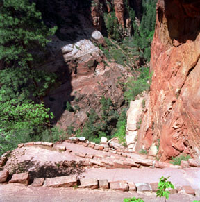
Walter's Wiggles
This is the view looking down the 21 switchbacks called Walter's Wiggles, a well maintained, paved portion of the trail leading from Refrigerator Canyon to the top of the fin at Scout Lookout.
Print No. A01-31-12
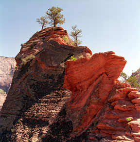
Sandstone Erosion
Sometimes, the interweaving of horizontal and cross-bedded sandstone becomes weathered to form interesting patterns like these along the fin to Angel's Landing.
Print No. A01-33-2
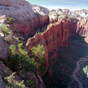
The Organ
As viewed from along the Angel's Landing Trail, The Organ (left center) is a narrow fin formed as the Virgin River carved a path along a meander of the river. The Organ acually sticks out, into Zion Canyon. Across the canyon, behind The Organ, is Cable Mountain to the left, and The Great White Throne to the right.
Print No. A01-33-3
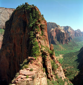
Trail to Angel's Landing
This is the last leg of the climb to Angel's Landing. It is also the most scenic and hairiest part of the trail. The main portion of Zion Canyon is seen to the south, behind Angel's Landing. Many of the steps are naturally-formed sandstone bedding planes and some sections have metal cables to assist with the steeper steps.
Print No. A01-33-4
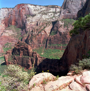
Refrigerator Canyon
Looking northwest from the top of Angel's Landing, the narrow fin on which the trail follows seems almost like a tight-rope walk, with Zion Canyon and the North Fork of the Virgin River to the right, and Refrigerator Canyon to the left. Scout Lookout lies in the notch on this side of the wider, rising portion of the fin. In the distance, the Virgin River enters The Narrows. A thin gray unit with a sloping surface can be seen at the very top the furthest mesas. This is the Jurassic-age Temple Cap Formation.
Print No. A01-33-9

Angel's Landing, North Wall
On the return trip, this image captures the view of Angel's Landing and its sheer north wall. Too small to be seen, there is at least one rock climber on this nearly 1,400-foot vertical face.
Print No. A01-33-11
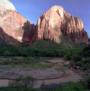
Red Arch Mountain
The end of the trail lies in the grassy area, across the Virgin River, at the foot of Red Arch Mountain (upper right). Here you can see where the base of the Navajo Sandstone cliffs and underlying vegetation cover mark the top of the Kayenta Formation. The cleft separating Red Arch Mountain from The Great White Throne (upper left) is called The Grotto.
Print No. A01-34-6
