
Multnomah Falls
On the sheer southern cliffs along the Columbia River Gorge, which makes up the Oregon/Washington state border, Multnomah Falls is 2-tiered, dropping a total of 620 feet (190 meters). That makes it the fourth highest waterfall in the United States.
Print No. A99NW-17-6

Above Wahkeena Falls
Wahkeena Falls is also along the Scenic Highway on the southern (Oregon) side of the Columbia River Gorge. Wahkeena is a Yakama tribe word meaning "most beautiful".
Print No. A99NW-16-2
Back to images of Oregon

Lower Falls of the McCloud River
The Falls of the McCloud River lie just south of Mount Shasta, in northern California. Here, just above the lower falls, potholes are formed in the basalt due to the scouring action of sediment carried by the river.
Print No. A99NW-23-6
Back to images of the Lava Beds vicinity of California
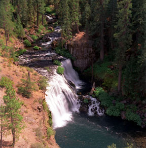
Middle Falls of the McCloud River
Located less than a mile upstream from the lower falls, the largest of the falls in the area are the middle falls with a drop of about 50 feet (15 meters).
Print No. A00-21-4
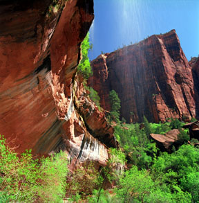
Lower Emerald Pool Falls
About 0.6 miles (1 Km) up the Emerald Pools Trail, seeps and surface water flow over an overhang of the Kayenta Formation of the Vermilion Cliffs. This leaves vertical streaks of black manganese oxide on the cliff wall.
Print No. A01-31-7
Back to images of Zion National Park, Utah

Maple Falls and Half Moon
Looking west from Box Canyon, Maple Falls cascades off Tatoosh Range on the south side of Mount Rainier.
Print No. A99NW-14-9
Back to images of Mount Rainier National Park, Washington
