
Mesquite Flat Sand Dunes No. 1
Mesquite Flat is on the north end of Death Valley. Winds blowing south down this portion of the valley run into the northern end of the Panamint Range. It's at this point that sand dunes build up on the valley floor. The Panamint Range also shields the dunes from winds coming up from the south. Near sunrise and sunset are the best times to view these dunes, as the shadows give depth to the scenery and texture to the surfaces.
Print No. A99-8-12
More Images of Mesquite Flat Sand Dunes
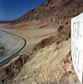
Sea Level at Badwater
This is the actual posted sign 282 feet (86 meters) above the salt flat below. Badwater is the lowest point in the western hemisphere. It is also the hottest point on the North American continent.
Print No. A99-10-6
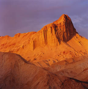
Manly Beacon, Golden Canyon
This view is across the badlands of Golden Canyon to Manly Beacon, one of the most photographed and recognized natural points in the southwest United States. Golden Canyon lives up to its name just before sunset as the eroded mudstones of the Furnace Creek Formation glow in the last sunlight.
Print No. A99-25-7
More Images of Sunsets

Zabriskie Point Badlands
This view is to the south from near Zabriskie Point. Manly Beacon is just to the west.
Print No. A99-11-11

Ventifact Hill
Just north of Badwater, this low ridgeline extends into the main valley. Due to the frequent strong winds (often bearing blowing sand) coming from the same direction, the basalt boulders on this ridge slowly get carved into wedged shapes called ventifacts.
Print No. A99-29-7
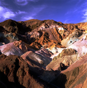
Artists Palette
These are the eroding river and lake deposits of the Late Miocene Artist Drive Formation. Interbedded with the deposits are a number of volcanic tuff beds. The various oxides create the wide variety of colors.
Print No. A01-28-9

Panamint View
This is the view east from near the trailhead to Telescope Peak on the west side of the valley. Telescope Peak is the highest point around at 11,048 feet (3,368 meters). From this view at about 8,500 feet above sea level, the valley lies a staggering 8,700 feet (2,650 meters) below. Taken in late April, the valley is already quite warm, yet snow (seen in the shadows) will persist into the summer on these high peaks.
Print No. A01-26-11
